-
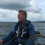
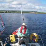
- Kevin Balmer steering his sloop KRYSTAL
-
- Dunluce Castle
Sailing the Coast of Northern Ireland: A sailing adventure and sea stories
by Steve Coleman
It was a morning so typical of summer in Northern Ireland. A moderate layer of stratus clouds overlay both land and ocean with a light breeze from the south and temperature around 19 degrees centigrade. About midway between Portstewart and Coleraine, I turned off the A2 onto the one-lane asphalt road that ran a quarter mile past two white stucco farm houses and two lush green pastures down to Seaton’s Marina on River Bann. I was going sailing! I did not expect that we would be returning with three reefs in the main.
My friend, Kevin Balmer, an Inspector and Instructor with the Royal Yachting Association, had invited me to crew with him along the coast. Walking down the pontoon (floating dock), I passed a few skiffs with outboard motors used in the river, which reputedly (according to locals at least)
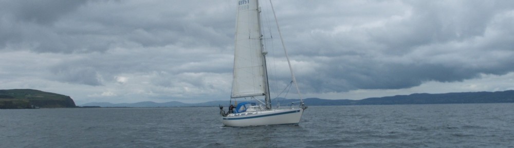
offers the best salmon and trout fishing in all of Ireland. Along the t-dock were twenty or so sailboats, and among them I found Kevin’s, a 36 foot Sigma sloop with the name Krystal in white letters on its red mainsail cover.
Kevin soon appeared in the parking lot, along with our other companion, Alec Brown, recently retired from the Belfast Police and now an avid sailor. Alec purchased a boat of his own and employed Kevin to teach him to sail it. Kevin’s primary job is Director of the Killyleagh Outdoor Recreation Center on Strangford Lough. At the center they provide a camp for Ulster’s school children, teaching them sailing, water safety, swimming, hiking and mountain climbing. It’s actually part of the curriculum for the school system and operates all year. But Kevin still finds time to sail and teach sailing, and he is looked up to as the master sailor along the northern coast.
Loading our seabags and groceries aboard, we first check the weather to confirm the bad news we’d already heard. We had planned for a sail to Port Ellen for an overnight visit on the island of Islay on the west coast of Scotland. For eight summers while vacationing in Portrush on Ireland’s northern coast, I had peered out across the sea at the island of Islay, visible only on the clearest days, and had thought what a great trip it would be to sail to there. But while today’s weather would be cloudy with a few scattered showers and a light breeze, not ideal but favorable enough for the trip over, tomorrow a deep low would move in, creating south winds, clocking to southwesterly at twenty-five knots and possibly higher. The next day would be no better, making a return to Ireland a terrible beat with heavy seas. Marine weather, by the way, is broadcast from Belfast by the Royal Coast Guard and from Malin Head by the Republic of Ireland Coast Guard. Malin Head is the northern-most point of Ireland, on the Inishowen Peninsula. Because it is to the west where most weather comes from, the Malin reports are the ones most meaningful to us.
So being a highly experienced and weather-wise sailor, Kevin decides that we should aim for Rathlin Island where we can spend the night and then return in the morning. Rathlin Island, a boomerang-shaped mass of rock lies about five miles off the northeastern corner of Northern Ireland, marking the boundary between the Atlantic and the North Channel of the Irish Sea. I’m not unhappy with this change of plans because the coastline between the River Bann and Rathlin rivals if not betters any in the world for scenic beauty.
It is quarter past ten when we get underway. The old expression, “sailing with the tides”, is a significant if not a required advantage in Northern Ireland. Although the rise and fall of springs is roughly two meters, flood and ebb currents can reach seven knots in certain locations. Since we will be going east, going with the flood is just about essential. Being the elder aboard, though I thoroughly dislike that age qualification, I’m given the helm as we motor downriver while Kevin and Alec ready the main. Of course, I love to steer. I’ve learned the way down the Bann from two previous trips with Kevin, but I’m still feeling just a little uncomfortable with greens on my port and reds to starboard on the way to sea. It somehow just doesn’t seem right. That’s the buoy system here, however, so you’d better get used to it. The river is kept dredged to four meters, but the channel is not wide and subject to shoaling along the marshy banks. Great numbers of sea fowl live along the shore. Ducks and loons dive underwater out of the way while Glaucous and big Blackback gulls dive and circle around you. We pass a row of pilings from an old plankless pier and see a cormorant perched on each, black wings held daintily out so the breeze will dry them.
The cow pastures to the east give way to the Portstewart golf course, its rolling topography beside green-gray grassed high dunes that border the river. Years ago the original mouth of the Bann was rerouted to the west in order to provide Portstewart with a long sandy beach on the Atlantic. As we make the turn to the west, and raise the main, we point toward the town of Castlerock with its castle-like gray church tower standing a mile off. Behind the village, Binevenagh Mountain is blue against the sky and to its right the famous cliffs of Downhill hang over the ocean. The final turn back to the right puts us at the barmouth, with its brown-rock jetties forming the pass. Formidable if not downright hazardous overfalls develop when a strong ebb comes out against a high northerly wind.
But with a flood tide and gentle winds, our passage today is easy and we proceed to sea. To the northwest is the wide mouth of Lough Foyle with the Inishowen Peninsula rising majestically beyond. The lough (meaning lake or bay) separates County Londonderry in Northern Ireland from the Inishowen Peninsula, part of Donegal in the Republic of Ireland. In the past, during “The Troubles”, Londonderry suffered from its proximity to the border with Donegal and was the scene of great strife from religious and political dissent. In present times, however, the border is open, the only indication of it being road signs telling you that speed limits will be posted in kilometers. A few miles down the lough beyond the high cliffs at Downhill, with its 18th Century Mussenden Temple presiding over the seascape, there is a ferry which runs from Magilligan Point across to the town of Greencastle on the Inishowen. Kevin says that Greencastle makes a good haven if seas are too rough for entering the River Bann.
A half mile out, Kevin and Alec unfurl the genoa. Killing the engine, I fall off to put Krystal on a broad reach, paralleling the strand of sandy beach, heading for Rathlin Island about thirty miles to the east. There is a light swell and just enough breeze to give us four knots.
Soon we are offshore of the village of Portstewart, marked by its old monastery sitting atop a rock promontory that overshadows a strip of shops and stores. On the east side is another golf course hanging over low cliffs running along the water.
On his cell phone Kevin calls his friends, Garreth and Joy McComb, who a few days earlier had sailed to Port Ellen and expect us to meet up with them there. Kevin tells Garreth the impending bad weather has changed our plans and strongly suggests they rendezvous with us at Rathlin Island. Reluctantly, Garreth agrees to follow our wise skipper’s advice and depart for Rathlin. Sailors who know Kevin, I discover, listen to him because they trust his knowledge, experience and judgment.
Half an hour after passing through the barmouth of the Bann, we arrive off Portrush, built upon a rocky finger of land jutting into the ocean. At the end of this peninsula is Remore Head, a great high rock edifice, protecting the town from storms that often blow in from the north. On a previous sail, we stopped in at Portrush’s venerable old harbor. A resort town from the 19th Century and the port for ships laden with coal to heat Northern Ireland’s homes, this vacation spot now provides a well-protected marina with a pontoon dockage for transients as well as local boats. It’s a busy little harbor for deep-sea fishing and recreational boating with about two dozen sailboats on moorings, their owners being members of a very active yacht club. A year before, I stood on Remore Head to witness their annual race around the Skerrie Islands that lie northeast of Portrush.
There is a photo, given to me by the Harbourmaster, “Big Richard” McKay, of the resident Lifeboat heading out of Portrush on a distress mission. The waves outside the harbor mouth are so tremendous that two-thirds of the hull of the careening Lifeboat are visible above the eight-foot high quay wall. The Lifeboats are manned by volunteers, who drop whatever they’re doing to go risk their lives to save others at sea.
We pass beneath the dark face of Remore Head, a lee shore for us today with rolling waves splashing high up its rocky point. Gulls and Puffins continually soar above in the updrafts created by its high face. As we come around to the east side of Portrush, we enter Skerrie Roads, which is the passage shoreward of the line of rock islands jutting out of the sea. The geology of Portrush and the Skerries Islands is highly complex. Created from successive sedimentary and volcanic activity, the Skerries appear to have once been parts of a layer of rock that was broken and forced up at an angle out of the sea. We sail by these great masses of upward slanting sun-bleached gray rock, splotched with grass, home only to sea birds, seals, and black rabbits. These islands provide a barrier against heavy seas, allowing gentler rolling waves to break along the beach. Despite the cold waters (60+- degrees Fahrenheit even in August) this strand is continually filled with vacationing Irish who brave the chill of wind and sea. Just inland of the beach is the famous Portrush Golf Course that attracts golfers from Europe and the U.S.
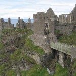
Parallel with the east end of the Skerrie chain, the strand ashore wraps around a point and runs into a fifty-foot high series of white limestone cliffs with sea-eroded caves in the face. On calm days one can canoe through them, Kevin tells me, but when there’s a significant onshore wind they can become deadly. Careful to avoid “The Storks”—rocky mounds awash—we spot the ruins of Dunluce Castle clinging to a rocky promontory high above the sea. Sorley Boy McDonald, laird of Ireland and Scotland constructed the castle in the 16th Century. Designed as both a fortress and a home, his family lived there until one dark, stormy night, the kitchen at the seaward end of the castle collapsed down the cliff into the sea, taking the poor cook to her death in the landslide. After that Lady McDonald refused to remain another night, and they moved inland to less dramatic but safer quarters.
Still on a broad reach with the wind on our port quarter, we notice the breeze is dying, but the flood current has increased, keeping us at a comfortable five knots over the ground.
“To head west now,” Kevin says, “you’d require more than a wee bit of engine. For mainly the current and not the wind is carrying you east.” Indeed, the instruments tell us our through the water speed is less than three knots.
For several days we’ve seen some of the “Tall Ships” which are gathering in Belfast on their summer tour. Alec points out one of the smaller three-masted schooners, apparently entering Ballintree Harbor, just east of Dunluce Castle. Having seen up close the little boulder-filled horseshoe-shaped harbor, exposed to wind and surf, I stare through binoculars as the schooner’s starboard anchor lowers to the water’s edge.
“’Tis not a wise move,” Kevin says. “That’s too much ship for that anchorage, I’ll tell you.”
And sure enough, within only a few minutes the schooner swings around and heads back out, realizing what we already knew. In spite of what sailing directions might tell you, local knowledge is so all important, particularly on a coast like this.
Portballintree, located low near the ocean lies below rolling hills beyond. Just to its east is the mouth of Bushmills River with the famous whiskey-making town of Bushmills a mile or so inland. From the town, the land of coastal river valley rises toward the great rock promontory called “The Giant’s Causeway”, considered to be one of the eight wonders of the world. Legend says that the giant, Finn McCool, whose severed hand is displayed in the center of the North Ireland Flag, made this huge rock edifice as a bridge to the ocean. At its seaward end, clusters of crystalline-shaped columns of basalt and lava-baked limestone stream out into the water, or run up the face of the high cliff, forming unique shapes. From our vantage point a quarter of a mile from the causeway, we can see the tourist bus coming down the side of the cliff, dwarfed to miniscule by the huge dark brown headland.
The northerly wind is abating some so that, when we pass beneath the tall cliffs and come to Benbane Head, Kevin considers starting the engine. Even though the sea is fairly calm, tidal currents eddy around the sea-sprayed rocks that lie beneath the cliffs, making too close a passage hazardous, especially with a high wind from seaward.
Rounding the headland, Krystal enters Rathlin Bay, lying between the boomerang-shaped island and the northern coast. We can see Rathlin Island fully now. Its western end, Point Bull, a high jagged wall of basalt is the roosting place for over 250,000 pelagic birds. Each June Gannets, Puffins, Kittiwakes, and any number of gulls and terns fly in, to mate and make their nests in the outcroppings. I once visited Point Bull during nesting season and was amazed not only at the sight of so many birds but also the deafening din of so much squawking. Today, we can see white Gannets soaring on their black-tipped six-foot-span wings diving over a school of small mackerel. Folding their wings they dive fiercely from up to fifty feet above the water and can swim down twenty feet deep in pursuit of prey.
Beyond the rocky crags and conical stack-like formations off Point Bull, the air has cleared, and we can see the yellowish cliffs of Islay rising in the distance, about thirty miles away. The tiny spec of a sail appears in that direction. Kevin calls again on the cell phone, reaching Garreth. They indeed are in route from Islay to Rathlin, and Kevin consults with him about the best approach.
“Make for Point Bull,” Kevin advises, “and then stay close to the island coming in.”
Our common destination, the harbor at Church Bay, lies within the crook of the boomerang on the southern side, facing the Irish coast. Around this five-mile long hump-backed island that lies at the beginning of the North Channel of the Irish Sea, there can be a half-dozen different tidal currents running at once. On a trip from Scotland to Rathlin, not only is catching the proper tide important, but it’s also critical to pick the correct end of the island to come around.
Off to starboard the mainland sweeps back to the east from Benbane head. As we sail across the Rathlin Bay I can pick out Portbradden, three “wee” houses once owned by fishermen, nestled beside the ocean below an enormous cliff. Beyond is a long sandy beach below white limestone outcroppings overlaid with steep pastures. At the far end is tiny Ballintoy Harbor, the “toy” in its name unitentionally describing the quaint tininess of this refuge for a few commercial fishermen. On farther eastward is Carrick-a-rede rope bridge suspended high above breaking waves, running between the shore and a volcanic conical island where salmon once ran in huge schools. Visible beyond, above the coast, sheep graze in stone-fenced green, green pastures, while the Glens of Antrim rise up the stately mountain behind.
Crossing Rathlin Bay we enjoy a light breeze while benign six-foot rollers that may have originated near Iceland gently lift and lower us in the sea. They finally will crash on the jetties at the port town of Ballycastle five miles away, or on towering Fair Head beyond, sending up great plumes of spray.
As we near Church Bay, the wind dies slowly as the afternoon wanes. Lowering our sails, we enter through the rock jetties and turn to the pontoon dock provided for pleasure boaters. Nearby the small ferry is loading up for the five-mile run back to Ballycastle. Tying up and connecting shore power, we’re ready for a Guinness and a walk about the island. By seven o’clock the McCombs arrive from Islay and tie up down the pier. We join together and plan dinner at Manor House, just up the way. A pleasurable supper is on our minds, knowing that tomorrow’s weather will not allow the repeat of such a pleasant day.
At 5:45 the next morning, Kevin knocked on the door of the v-berth berth bow cabin and thrust his head in.
“Time we were away,” he said. “Weather’s moving in sooner than we thought.” Then he was up and out in the cockpit. Kevin’s about 5’ 10”, wiry, and very athletic. A snow skiing instructor as well as a sailor, he moves around that boat like a cat.
Swinging my legs out of the sleeping bag and sitting up, I nodded and glanced up at the Plexiglas hatch cover, noting it is splotched with raindrops. Being 6’ 3” and weighing in at 280, I am not exactly built to the same scale as this boat, so it takes me an extra minute to dress. When I emerge out into the cockpit, zipping my foul weather jacket, I find that Alec and Kevin are down the dock helping Garreth and Joy get underway. One look at the dark grey clouds moving over the mainland to the south and an occasional gust moaning in the rigging tells me that the low pressure cell must be getting close.
My companions return as Garreth’s INTREPID motors by. In short order we get underway too, and follow in their wake out of the rock jetties into Church Bay. Kevin gives me the helm, and I head up toward the buoy that marks the submerged remains of HMS DRAKE, sunk there by a German U-boat in World War II. Kevin and Alec raise the main with one reef in it and then unfurl the genoa. Since the wind is so light, and because Garreth and Joy are already ahead by two hundred yards, I question setting the reef in the main. After all, sailing in company with another boat is always something of race, isn’t it?
“Aye, just wait and see,” Kevin says, pleasantly. Almost on cue, the Irish Coast Guard Station at Malin Head broadcasts a weather bulletin. He slips below to change over to channel 89, and we hear a gale warning with Force 7 or 8 winds expected. Switching back to channel 16, Kevin comes back on deck with three lifejackets and safety harnesses, needing to say no more about the reef in the main. He instructs me to point toward Benbane Head on the mainland coast, a heading of 260. Soon we emerge out beyond Church Bay to the southwest of Point Rue, the eastern end of Rathlin Island. Now the hour-old ebb current will carry us west. In another hour, the ebbing stream will race through Rathlin Bay at seven knots, and the mighty whirlpool, Slough-na-more (swallow of the sea), will rage between Point Rue and Ballycastle.
As we sail out farther from the chalky cliffs of the island, the light breeze becomes disturbed with occasional gusts. Scudding gray clouds continue to pour over the mainland and over the bay. INTREPID is still ahead and even slightly upwind of us, flying full main and jib, but even with our reefed sail, we’re catching up. About a half mile from Benbane Head, the steadily increasing wind gusts harder out of the south, and I work at the helm as we list hard in the powerful knocks.
“Here comes the wind,” Alec says, pointing. I look to see the band of ripples rolling toward us from the south. It hits us with a great “whompf” of the sails, and I hang on to the helm through the deep heel to starboard, trying to ease the pressure without fully rounding up. This burst of wind was not just a gust but a more permanent blast of air rushing into the cell of low pressure charging toward us from the west. The anemometer needle had pretty well steadied between twenty and twenty-five knots. Calling to Alex to man the halyard, Kevin jumps up on the port gunwhale, clips his harness on to the safety line and makes his way to the mast. I head up, and they put a second reef in the main. When I fall back off, a thirty plus gust heels us heavily and our speed through the water moves up to seven knots. With Kevin back in the cockpit, they reef the jib by a third.
Windwise, we were below INTREPID by seventy yards but abreast by now when we see her genoa luffing wildly. They apparently were reefing their jib and the sheet got away from Joy in the high wind. In a few moments, however, they get things under control and furl it completely, sailing only on the main. This cost them the lead as we round the head, and we shoot on past in our undeclared race. (Garreth explained later that they lacked sufficient crew to reef the mainsail in those winds, so they decided to proceed solely by the mainsail for the remainder of the trip.)
About three cables (a cable is 200 yards) offshore, the wind spilled over the high headlands. So beautiful on the calm day before, these tall faces are now dark and ominous in the mist and the rain. Millions of years of erosion have carved hundred-yard wide indentations in the rock, much like the serrations in a knife blade, and this irregularity creates a confusing pattern of wind gusts and shelter that make steering very interesting to say the least. Expecting the wind to clock to the west as predicted, we remain fairly close in, choosing to stay upwind. Passing by the projecting headlands, we slow in the lee of the cliffs only to take a hard knock as we pass the next hollowed out inlet.
With the rain pelting me in the face as I steer past one of these indentations named Port Espagna, I easily can imagine the historic wreck of the GIRONA that happened there in 1588. The Spanish galleon, one of the Armada escaping from both storms and the British fleet, became trapped by high winds and seas coming from the north. A square-rigged ship, GIRONA was unable to beat its way away from the coast and crashed into the rocks at this place. Its surviving sailors struggled to the top of the high cliff, only to meet the McDonalds, who ruled the coast. As each sailor topped the cliff, he was slain by the very inhospitable Scot-Irish gang.
In spite of Krystal’s modern sloop design that allows us to beat into the wind, we’re still glad the storm we’re in is coming out of the south. In this condition seas are not so rough along these cliffs, even though eddy and overfalls from the ebbing tide would trouble us severely if we were in any closer. As a result of that ebbing tide, our speed over the ground has increased significantly. Even though we don’t have the rush of current that runs through Rathlin Bay, there’s plenty of push adding to the speed from the wind.
With the rain slackening a bit—Alec has taken the helm and I can dry off under the dodger—we enter Skerries Roads, that inner side of the line of rocky islands east of Portrush. Away from the lee of the cliffs that we’ve left behind us, we seem to be flying past the islands now, and enjoying a respite from the rain. First Belfast Coast Guard and then the Republic of Ireland station at Malin Head warn again of impending gales. We’re taking occasional gusts up to thirty-five knots, but the steady wind is only about twenty or so. Coming back around Remore Head at Portrush, we’re happy to see that the breeze has not yet clocked to the southwest, so that our course of 240 back to the entrance to River Bann will not be the unpleasant beat or tacking battle we might have had if we’d left Rathlin any later in the morning. Giant blue-gray clouds loom over the green hills to the south and west, threatening to drench us thoroughly before we make the barmouth.
Good fortune is with us, however, as we near the river and Kevin cranks up the diesel. I’ve taken the helm again so that Alec can assist in furling the jib. I make the turn, careful to clear the wave-splashed east jetty and steady on the leading marks (a range, we call it). The clouds are still rolling towards us, but we’re headed inside at least, no longer worried about the threat of gale force winds on our nose at sea, which could have made the narrow passage through the rock jetties treacherous. Not far behind, INTREPID prepares to enter the pass and is also safe.
Relaxing a bit, we congratulate ourselves and tell a joke or two. Meanwhile I, the American at the helm, more concerned with the banter than the course, point the bow to pass the first red day marker down our starboard side. Intent upon listening to Kevin report that our run from Rathlin today was a record two hours and fifty-five minutes, I’m congratulating myself for being not a bad helmsman. I fail to notice, however, that the depth gauge is going from four meters to two. Alec looks up, suddenly notices what I’m doing, and waves and shouts.
“Go right, go right!”
The light goes on in my preoccupied brain and I spin the wheel clockwise. The bow yaws over and aims for the channel just in time. It’s not “Red, Right, Return”, I remember, slapping my hand to my head. In this country it’s “Green, Right, Return.” Safely back in deep water, I apologize, explaining that about once every summer in Ireland, after driving on the left for weeks, at least once I’ll inadvertently swing over to the right and face oncoming traffic.
“Well, it’s not hard to understand,” Kevin says graciously. “If you’ve been driving on the right and passing red markers to starboard all your life, it’s easy to forget.”
“It doesn’t make it any less stupid, though,” I say. “I nearly had to get out and push.” The two of them laugh good-naturedly as they prepare to lower and cover the main. Even so, I notice as we traverse the final four miles to Seaton’s Marina each of them gives an occasional glance down the channel, just in case. I remind myself once more that the time you’re most likely to screw up is when you’ve passed a critical period and then let yourself become a little too relaxed and less vigilant.
We reach the pier and tie up just as the real deluge begins. Happily, we all lay below to the cabin. Kevin prepares a great Irish breakfast for us and for the McCombs, who come rushing in out of the terrific rain. From the comfort of Krystal‘s wee cabin, we listen to the Force 6 or 7 wind hum ominously through the rigging while we share in the “craic”—friendly conversation and banter as only the Irish can make. Sailing on the magnificent north coast of Ireland is a wonderful experience, I can tell you, but you’d better pay close attention to currents, weather and the other-way-round color of beacons and buoys.
P.S. You also might enjoy seeing photos from a sailing adventure my friends, Freddie and Hilary Moran who sail from Edinburg, Scotland every summer. Take a look at their trip around Ireland in 2009. Circumnavigation of
Ireland 2009 – http://www.maloyachts.se/Default.aspx?tabid=251
")